Arizona’s trusted NDAA‑compliant drone surveying for construction.

  • Home
  • Stockpile Measurement
  • Construction Mapping
  • Stockpile Volumetrics
  • Forestry Mapping
  • Blog
  • More
    • Home
    • Stockpile Measurement
    • Construction Mapping
    • Stockpile Volumetrics
    • Forestry Mapping
    • Blog
Push to take flight

  • Home
  • Stockpile Measurement
  • Construction Mapping
  • Stockpile Volumetrics
  • Forestry Mapping
  • Blog
Push to take flight

Stockpile Measurement for Northern Arizona Contractors

 Accurate yardage. Faster decisions. Zero guesswork. 

 FlagAerial delivers precise drone‑based stockpile measurements for construction sites, material yards, quarries, asphalt plants, and aggregate operations across Northern Arizona. 

        Local. Reliable. Accurate. 

flagstaff-aggregate-yard-drone-photo
Why Stockpile Measurement Matters

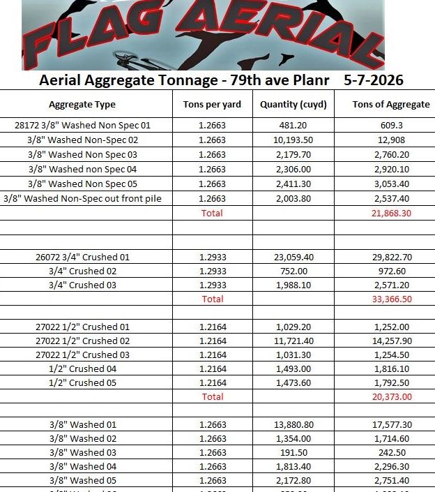
Material moves fast, and costs change daily. We offer accurate, repeatable stockpile measurements so your team always knows exactly what’s on the ground. Whether you're selling material, ordering more, reconciling inventory, or tracking production, our drone stockpile measurement provides the reliable data you need.

What You Get

aerial-stockpile-measurement-map

✔ Accurate Yardage

 We deliver precise cut/fill and volume calculations for every pile on site. 

✔ Faster Inventory Decisions

 Know exactly how much material you have before you bid, order, or invoice. 

✔ Safe, Fast, and Non‑Disruptive

 We fly the yard without interrupting operations or putting anyone on a pile. 

✔ Professional‑Grade Hardware

Every flight uses secure, reliable equipment suitable for commercial and municipal projects. 

✔ Clean, Easy‑to‑Read Reports

 Color‑coded maps, labeled piles, and clear volume numbers your whole team can understand. 

Stockpile Measurement for Northern Arizona Contractors


  • Aggregate yards
  • Asphalt plants
  • Concrete suppliers
  • Construction companies
  • Quarries
  • Material pits
  • Municipal yards
  • Landfill operations

If you move material, sell material, or track material — this service pays for itself.

How It Works

1. We Fly the Yard

A fast, safe drone flight captures high‑resolution data across the entire site.

2. We Process the Volumes

Every pile is outlined, measured, and calculated using industry-standard volumetric tools, ensuring accurate construction material measurement.  Our streamlined workflow ensures every pile is outlined, measured, and calculated with industry‑standard volumetric tools. 

3. You Get the Numbers

 We provide a comprehensive report with cut/fill data, volume changes, and a visual map of every stockpile on site. 

4. Repeat as Needed

Weekly, monthly, or quarterly flights keep your inventory accurate year‑round. 

Why Northern Arizona Contractors Choose FlagAerial


  • Local Flagstaff‑based operator
  • Professional Grade Equipment
  • Fast turnaround
  • Accurate, repeatable measurements
  • Clear communication and contractor‑focused reporting
  • Trusted by construction sites, schools, and material yards across the region

You get real numbers — not estimates.

Ready to Measure Your Yard?

FlagAerial provides accurate stockpile measurement for contractors across Northern Arizona.

Book a flight today and get your yard measured with precision. We offer accurate construction material measurement and drone stockpile reporting in Flagstaff, Prescott, Williams, Winslow, and all of Arizona. 

FlagAerial

scott@flagaerial.com 9286067753

FlagAerial, LLC.

Flagstaff AZ. USA

928.606.7753

Copyright © 2026 FlagAerial - All Rights Reserved.

Powered by