⭐ Documenting 100,000+ Cubic Yards of Recycled Concrete in Phoenix


.JPG/:/rs=w:370,cg:true,m)

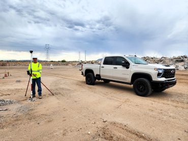
What We do

Volumetric Surveys That Actually Mean Something
Stockpile numbers matter — for billing, inventory, and end‑of‑month reporting. Here’s a real example from one of our aggregate yards, where we utilize drone mapping for accurate data collection.
Volumetric Inventory – Multi‑Pile Yard
We deliver cut/fill, volume diff, and clean outlines so you know exactly what’s on the ground, including detailed tree counts which can also assist in wildfire mitigation efforts.

High‑Accuracy Measurements for Big Material Moves
Large piles? No problem. Drone mapping allows for accurate 3D models that traditional methods simply can't match. This high-quality data is essential for maintaining clean books and streamlined operations, and it's invaluable for applications like tree counts and wildfire mitigation.
Roadway & Infrastructure Mapping
Progress Documentation for City & Commercial Projects
Drone mapping isn’t just for dirt and rock. Cities and contractors use it for intersections, roundabouts, utilities, and as-builts, including tree counts for better planning and wildfire mitigation efforts.
Roundabout Infrastructure Survey – Flagstaff
Clean aerials help engineers, inspectors, and project managers stay aligned.
Progress Documentation for City & Commercial Projects
Progress Documentation for City & Commercial Projects
Weekly or monthly drone mapping flights provide you with a clear visual timeline of your project — eliminating guesswork and outdated photos. This method is also ideal for tree counts and wildfire mitigation efforts, ensuring accurate reporting and effective communication while keeping everyone accountable.
Stockpile Volume Flight Near Prescott Airport | Northern Arizona Drone Mapping
When you’re running a job near the Prescott Airport, you don’t have time to mess around with bad numbers or slow turnarounds. This week I flew a full stockpile volume mapping job right next to the airport, giving the crew clean quantities and a high‑accuracy dataset they could use immediately.
Contractors in Northern Arizona deal with tight schedules, tight budgets, and even tighter material counts. That’s where drone mapping makes life easier. One quick flight gives you accurate stockpile measurements, updated site conditions, and high‑resolution mapping without shutting down operations or waiting on a survey crew.

Aerial Progress Update: Kinsey School Rebuild in Flagstaff
Secure Drone Mapping in Northern Arizona
Why Contractors Use Aerial Progress Flights
Secure Drone Mapping in Northern Arizona

Back in January, I flew the first aerial survey of the new Kinsey School here in Flagstaff. At that point, the site was just breaking ground — early grading, utilities starting, and the first signs of layout work taking shape. Fast-forward to this past Friday, and the progress is unreal.
FlagAerial returned to the site for a second round of high-resolution aerial mapping using drone mapping technology and progress documentation. This allowed the project team to get a clean, accurate look at how far the job has moved in just a few months, including essential tree counts for future wildfire mitigation efforts.
From Dirt Work to Defined Foundation
Why Contractors Use Aerial Progress Flights
Secure Drone Mapping in Northern Arizona
January’s flight captured the early stages: Rough grading, initial cut/fill work, utility trenching, and early site prep, all of which can be enhanced through drone mapping for more accurate assessments. Friday’s flight shows a completely different picture: foundations forming, utilities further along, a clearly defined site layout, and heavy equipment moving fast. The entire footprint is taking shape, including tree counts for effective wildfire mitigation planning. Side-by-side, the transformation is obvious — and that’s exactly why progress flights matter.
Why Contractors Use Aerial Progress Flights
Why Contractors Use Aerial Progress Flights
Local, NDAA‑Compliant, and Built for Northern Arizona
Flagstaff projects move quickly, and the Kinsey School rebuild is no exception. Aerial documentation through drone mapping provides contractors and project managers with: A clear record of site development, visual proof of progress for clients and stakeholders, accurate, high-level views you can’t get from the ground, clean images for reporting, scheduling, and communication, and a consistent timeline of the job from start to finish. Whether it’s a school, commercial pad, subdivision, or utility project, aerial updates, including tree counts for wildfire mitigation, keep everyone aligned.
Local, NDAA‑Compliant, and Built for Northern Arizona
Local, NDAA‑Compliant, and Built for Northern Arizona
FlagAerial is fully NDAA-compliant, ensuring that our drone mapping services are approved for school districts, public agencies, and government-related projects throughout Northern Arizona. There are no restricted hardware issues and no compliance concerns—just clean, accurate aerial data, including tree counts and insights for wildfire mitigation.
Being based in Flagstaff allows us to provide fast turnaround times and simple communication.
What’s Next for the Kinsey School Site
FlagAerial will continue flying the Kinsey School as it progresses through major milestones, utilizing drone mapping to document each phase. Each flight adds another layer to the project’s story — from foundation to framing to finish. This advanced technology also allows for accurate tree counts, which are essential for future wildfire mitigation efforts. Contractors receive the documentation they need, the district gets a clear record of progress, and Flagstaff enjoys watching a new school take shape from the air.
📌 Final Takeaway

The Kinsey School rebuild is progressing rapidly, and aerial progress flights are the best way to capture the story from start to finish. FlagAerial is proud to support local construction with accurate drone mapping, tree counts, and NDAA-compliant site documentation across Northern Arizona, which also aids in wildfire mitigation. If your project requires monthly or milestone flights, FlagAerial is ready to fly.
FlagAerial Is Now Fully NDAA‑Compliant

Secure Drone Mapping in Northern Arizona
Back in January, I flew the first aerial survey of the new Kinsey School here in Flagstaff. At that point, the site was just breaking ground — early grading, utilities starting, and the first signs of layout work taking shape. Fast-forward to this past Friday, and the progress is unreal.
FlagAerial returned to the site for a second round of high-resolution aerial mapping using drone mapping technology and progress documentation. This allowed the project team to get a clean, accurate look at how far the job has moved in just a few months, including essential tree counts for future wildfire mitigation efforts.
Why NDAA Compliance Matters
January’s flight captured the early stages: Rough grading, initial cut/fill work, utility trenching, and early site prep, all of which can be enhanced through drone mapping for more accurate assessments. Friday’s flight shows a completely different picture: foundations forming, utilities further along, a clearly defined site layout, and heavy equipment moving fast. The entire footprint is taking shape, including tree counts for effective wildfire mitigation planning. Side-by-side, the transformation is obvious — and that’s exactly why progress flights matter.
What This Means for Northern Arizona
Flagstaff projects move quickly, and the Kinsey School rebuild is no exception. Aerial documentation through drone mapping provides contractors and project managers with: A clear record of site development, visual proof of progress for clients and stakeholders, accurate, high-level views you can’t get from the ground, clean images for reporting, scheduling, and communication, and a consistent timeline of the job from start to finish. Whether it’s a school, commercial pad, subdivision, or utility project, aerial updates, including tree counts for wildfire mitigation, keep everyone aligned.
NDAA‑Compliant Services Now Available
FlagAerial is fully NDAA-compliant, ensuring that our drone mapping services are approved for school districts, public agencies, and government-related projects throughout Northern Arizona. There are no restricted hardware issues and no compliance concerns—just clean, accurate aerial data, including tree counts and insights for wildfire mitigation.
Being based in Flagstaff allows us to provide fast turnaround times and simple communication.
Who Should Use NDAA‑Compliant Drone Mapping
FlagAerial will continue flying the Kinsey School rebuild as it progresses through major milestones, utilizing drone mapping to document each phase. Each flight adds another layer to the project’s story — from foundation to framing to finish. This advanced technology also allows for accurate tree counts, which are essential for future wildfire mitigation efforts. Contractors receive the documentation they need, the district gets a clear record of progress, and Flagstaff enjoys watching a new school take shape from the air.
Now Scheduling NDAA‑Required Projects
The Kinsey School rebuild is progressing rapidly, and aerial progress flights are the best way to capture the story from start to finish. FlagAerial is proud to support local construction with accurate drone mapping, tree counts, and NDAA-compliant site documentation across Northern Arizona, which also aids in wildfire mitigation. If your project requires monthly or milestone flights, FlagAerial is ready to fly.
Expert Surveying Services
1st Flight
3 Months Later
3 Months Later

Back in January, I flew the first aerial survey of the new Kinsey School here in Flagstaff. At that point, the site was just breaking ground — early grading, utilities starting, and the first signs of layout work taking shape. Fast-forward to this past Friday, and the progress is unreal.
FlagAerial returned to the site for a second round of high-resolution aerial mapping using drone mapping technology and progress documentation. This allowed the project team to get a clean, accurate look at how far the job has moved in just a few months, including essential tree counts for future wildfire mitigation efforts.
3 Months Later
3 Months Later
3 Months Later
January’s flight captured the early stages: Rough grading, initial cut/fill work, utility trenching, and early site prep, all of which can be enhanced through drone mapping for more accurate assessments. Friday’s flight shows a completely different picture: foundations forming, utilities further along, a clearly defined site layout, and heavy equipment moving fast. The entire footprint is taking shape, including tree counts for effective wildfire mitigation planning. Side-by-side, the transformation is obvious — and that’s exactly why progress flights matter.
What Repeat Flights Reveal

1. Earthwork Progress
Back in January, I flew the first aerial survey of the new Kinsey School here in Flagstaff. At that point, the site was just breaking ground — early grading, utilities starting, and the first signs of layout work taking shape. Fast-forward to this past Friday, and the progress is unreal.
FlagAerial returned to the site for a second round of high-resolution aerial mapping using drone mapping technology and progress documentation. This allowed the project team to get a clean, accurate look at how far the job has moved in just a few months, including essential tree counts for future wildfire mitigation efforts.
2. Cut/Fill Changes
January’s flight captured the early stages: Rough grading, initial cut/fill work, utility trenching, and early site prep, all of which can be enhanced through drone mapping for more accurate assessments. Friday’s flight shows a completely different picture: foundations forming, utilities further along, a clearly defined site layout, and heavy equipment moving fast. The entire footprint is taking shape, including tree counts for effective wildfire mitigation planning. Side-by-side, the transformation is obvious — and that’s exactly why progress flights matter.
3. Updated Quantities
Flagstaff projects move quickly, and the Kinsey School rebuild is no exception. Aerial documentation through drone mapping provides contractors and project managers with: A clear record of site development, visual proof of progress for clients and stakeholders, accurate, high-level views you can’t get from the ground, clean images for reporting, scheduling, and communication, and a consistent timeline of the job from start to finish. Whether it’s a school, commercial pad, subdivision, or utility project, aerial updates, including tree counts for wildfire mitigation, keep everyone aligned.
4. Documentation for Owners & Inspectors
FlagAerial is fully NDAA-compliant, ensuring that our drone mapping services are approved for school districts, public agencies, and government-related projects throughout Northern Arizona. There are no restricted hardware issues and no compliance concerns—just clean, accurate aerial data, including tree counts and insights for wildfire mitigation.
Being based in Flagstaff allows us to provide fast turnaround times and simple communication.
5. Better Planning & Scheduling
FlagAerial will continue flying the Kinsey School rebuild as it progresses through major milestones, utilizing drone mapping to document each phase. Each flight adds another layer to the project’s story — from foundation to framing to finish. This advanced technology also allows for accurate tree counts, which are essential for future wildfire mitigation efforts. Contractors receive the documentation they need, the district gets a clear record of progress, and Flagstaff enjoys watching a new school take shape from the air.
If you want accurate, repeatable site data for your next project, we can help.
The Kinsey School rebuild is progressing rapidly, and aerial progress flights are the best way to capture the story from start to finish. FlagAerial is proud to support local construction with accurate drone mapping, tree counts, and NDAA-compliant site documentation across Northern Arizona, which also aids in wildfire mitigation. If your project requires monthly or milestone flights, FlagAerial is ready to fly.
Drone Mapping Construction Projects: What You Need to Know
Back in January, I flew the first aerial survey of the new Kinsey School here in Flagstaff. At that point, the site was just breaking ground — early grading, utilities starting, and the first signs of layout work taking shape. Fast-forward to this past Friday, and the progress is unreal.
FlagAerial returned to the site for a second round of high-resolution aerial mapping using drone mapping technology and progress documentation. This allowed the project team to get a clean, accurate look at how far the job has moved in just a few months, including essential tree counts for future wildfire mitigation efforts.
Why Drone Mapping Works in Arizona
January’s flight captured the early stages: Rough grading, initial cut/fill work, utility trenching, and early site prep, all of which can be enhanced through drone mapping for more accurate assessments. Friday’s flight shows a completely different picture: foundations forming, utilities further along, a clearly defined site layout, and heavy equipment moving fast. The entire footprint is taking shape, including tree counts for effective wildfire mitigation planning. Side-by-side, the transformation is obvious — and that’s exactly why progress flights matter.
Common Uses on Job Sites
Flagstaff projects move quickly, and the Kinsey School rebuild is no exception. Aerial documentation through drone mapping provides contractors and project managers with: A clear record of site development, visual proof of progress for clients and stakeholders, accurate, high-level views you can’t get from the ground, clean images for reporting, scheduling, and communication, and a consistent timeline of the job from start to finish. Whether it’s a school, commercial pad, subdivision, or utility project, aerial updates, including tree counts for wildfire mitigation, keep everyone aligned.
Faster Turnaround
FlagAerial is fully NDAA-compliant, ensuring that our drone mapping services are approved for school districts, public agencies, and government-related projects throughout Northern Arizona. There are no restricted hardware issues and no compliance concerns—just clean, accurate aerial data, including tree counts and insights for wildfire mitigation.
Being based in Flagstaff allows us to provide fast turnaround times and simple communication.
Supporting Better Decisions
FlagAerial will continue flying the Kinsey School rebuild as it progresses through major milestones, utilizing drone mapping to document each phase. Each flight adds another layer to the project’s story — from foundation to framing to finish. This advanced technology also allows for accurate tree counts, which are essential for future wildfire mitigation efforts. Contractors receive the documentation they need, the district gets a clear record of progress, and Flagstaff enjoys watching a new school take shape from the air.
The Kinsey School rebuild is progressing rapidly, and aerial progress flights are the best way to capture the story from start to finish. FlagAerial is proud to support local construction with accurate drone mapping, tree counts, and NDAA-compliant site documentation across Northern Arizona, which also aids in wildfire mitigation. If your project requires monthly or milestone flights, FlagAerial is ready to fly.
How Drone Volumetrics Improve Accuracy in Construction

Back in January, I flew the first aerial survey of the new Kinsey School here in Flagstaff. At that point, the site was just breaking ground — early grading, utilities starting, and the first signs of layout work taking shape. Fast-forward to this past Friday, and the progress is unreal.
FlagAerial returned to the site for a second round of high-resolution aerial mapping using drone mapping technology and progress documentation. This allowed the project team to get a clean, accurate look at how far the job has moved in just a few months, including essential tree counts for future wildfire mitigation efforts.
Faster Data Collection
January’s flight captured the early stages: Rough grading, initial cut/fill work, utility trenching, and early site prep, all of which can be enhanced through drone mapping for more accurate assessments. Friday’s flight shows a completely different picture: foundations forming, utilities further along, a clearly defined site layout, and heavy equipment moving fast. The entire footprint is taking shape, including tree counts for effective wildfire mitigation planning. Side-by-side, the transformation is obvious — and that’s exactly why progress flights matter.
Improved Accuracy
Flagstaff projects move quickly, and the Kinsey School rebuild is no exception. Aerial documentation through drone mapping provides contractors and project managers with: A clear record of site development, visual proof of progress for clients and stakeholders, accurate, high-level views you can’t get from the ground, clean images for reporting, scheduling, and communication, and a consistent timeline of the job from start to finish. Whether it’s a school, commercial pad, subdivision, or utility project, aerial updates, including tree counts for wildfire mitigation, keep everyone aligned.
Better Project Tracking
FlagAerial is fully NDAA-compliant, ensuring that our drone mapping services are approved for school districts, public agencies, and government-related projects throughout Northern Arizona. There are no restricted hardware issues and no compliance concerns—just clean, accurate aerial data, including tree counts and insights for wildfire mitigation.
Being based in Flagstaff allows us to provide fast turnaround times and simple communication.
Reduced Risk of Costly Errors
FlagAerial will continue flying the Kinsey School rebuild as it progresses through major milestones, utilizing drone mapping to document each phase. Each flight adds another layer to the project’s story — from foundation to framing to finish. This advanced technology also allows for accurate tree counts, which are essential for future wildfire mitigation efforts. Contractors receive the documentation they need, the district gets a clear record of progress, and Flagstaff enjoys watching a new school take shape from the air.
The Kinsey School rebuild is progressing rapidly, and aerial progress flights are the best way to capture the story from start to finish. FlagAerial is proud to support local construction with accurate drone mapping, tree counts, and NDAA-compliant site documentation across Northern Arizona, which also aids in wildfire mitigation. If your project requires monthly or milestone flights, FlagAerial is ready to fly.
Why Tree Counts Matter More Than Ever in Arizona

Understanding Your Forest: Why Accurate Tree Counts Matter
Back in January, I flew the first aerial survey of the new Kinsey School here in Flagstaff. At that point, the site was just breaking ground — early grading, utilities starting, and the first signs of layout work taking shape. Fast-forward to this past Friday, and the progress is unreal.
FlagAerial returned to the site for a second round of high-resolution aerial mapping using drone mapping technology and progress documentation. This allowed the project team to get a clean, accurate look at how far the job has moved in just a few months, including essential tree counts for future wildfire mitigation efforts.
Drone Mapping Makes Tree Counts Faster and More Accurate
January’s flight captured the early stages: Rough grading, initial cut/fill work, utility trenching, and early site prep, all of which can be enhanced through drone mapping for more accurate assessments. Friday’s flight shows a completely different picture: foundations forming, utilities further along, a clearly defined site layout, and heavy equipment moving fast. The entire footprint is taking shape, including tree counts for effective wildfire mitigation planning. Side-by-side, the transformation is obvious — and that’s exactly why progress flights matter.
Why Tree Counts Matter for Wildfire Mitigation
Flagstaff projects move quickly, and the Kinsey School rebuild is no exception. Aerial documentation through drone mapping provides contractors and project managers with: A clear record of site development, visual proof of progress for clients and stakeholders, accurate, high-level views you can’t get from the ground, clean images for reporting, scheduling, and communication, and a consistent timeline of the job from start to finish. Whether it’s a school, commercial pad, subdivision, or utility project, aerial updates, including tree counts for wildfire mitigation, keep everyone aligned.
Supporting Thinning, Forestry, and Environmental Projects
FlagAerial is fully NDAA-compliant, ensuring that our drone mapping services are approved for school districts, public agencies, and government-related projects throughout Northern Arizona. There are no restricted hardware issues and no compliance concerns—just clean, accurate aerial data, including tree counts and insights for wildfire mitigation.
Being based in Flagstaff allows us to provide fast turnaround times and simple communication.
A Smarter Way to Manage Your Land
FlagAerial will continue flying the Kinsey School rebuild as it progresses through major milestones, utilizing drone mapping to document each phase. Each flight adds another layer to the project’s story — from foundation to framing to finish. This advanced technology also allows for accurate tree counts, which are essential for future wildfire mitigation efforts. Contractors receive the documentation they need, the district gets a clear record of progress, and Flagstaff enjoys watching a new school take shape from the air.